14 Peaks Of Norfolk
Norfolk’s toughest one day walking challenge — 14 peaks, 23.7 miles and 820m of climbing along the stunning Norfolk coast.

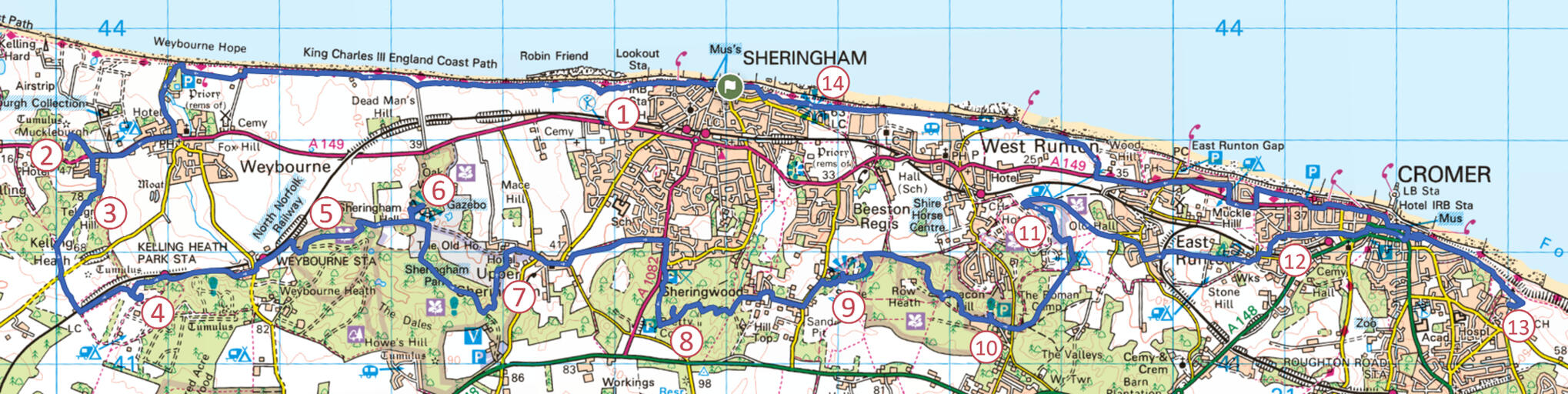
The Route
The start/finish in the seaside town of Sheringham which offers ample parking and rail/bus access. Also shops, pubs & cafes in abundance.
Distance: 23.8m/38.3 km - approx. 8-10 hours.
Elevation: 819m - Whilst this is still Norfolk the walk has been designed to cover as many hills as possible in one of the flattest counties in the UK.
Multiple places along the way for food, drinks and resting weary legs. These include Weybourne, Kelling Heath & Cromer.
A perfect escape route presents itself after peak 7 where the walk can be halved and gone back to another day.
Route has been designed to keep off roads wherever possible, however there is still some distance especially around Cromer.
The Peaks
Skelding Hill - 49m
Muckleburgh Hill - 68m
Telegraph Hill - 78m
Kelling Heath - 69m
Sheringham Park Ridge - 66m
Sheringham Park Gazebo - 76m
Sheringham Wood Viewpoint - 79m
Pretty Corner - 102m
Stone Hill - 91m
Beacon Hill - 105m
Incleborough Hill - 79m
Howard's Hill - 57m
Cromer Lighthouse - 75m
Beeston Bump - 63m